Here is a little photo journal of the trek...
The trip started out with a ride in this gringo-safari-mobile. I am not really sure what the people of Santa Marta thought of this vehicle filled with pasty white tourists as it made its way through their streets, but I am sure many of them were secretly grinning inside as we rumbled past.
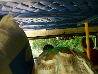
The gringo-safari-mobile drove us through Tayrona National Park and then turned inland, tackling rocky dirt roads, fording streams and hugging steep cliffsides as we climbed the hills. On the right is what it looked like from the back seat (behind the sacks of food).
After a filling lunch of mystery-meat sandwiches we began to hike, and were on the trail for about 4 hours the first day. We stopped twice along the way, once for oranges and once for watermelon slices. I began to realize that the reports of "tons of food" coming other travelers returning from the trek were not exaggerations.
At one point our guide, Wilson, pointed out this special mountain to us. He called it "la teta de (someone's name I don't remember)"... meaning... it is a boob mountain. With a nipple. See?
The first night we slept in hammocks with mosquito nets. I had heard that sleeping the whole night in a hammock was uncomfortable, but I actually found it awesome - you are all cocooned up there in your little nest and it is quite comfy.
We woke up on Day 2 and hiked down to a waterfall just below our camp! Part of getting down the steep trail involved descending on a little fixed rope:
We climbed down until we were just above the waterfall, and then we actually climbed down the falls themselves, parts of which involved scrambling down the rocks on the side and parts of which involved descending through the water, while holding on to the plants growing on the edges.
 At the bottom, we actually swam in the falls, and walked under the rushing water until we were in the calm bit on the inside. Yes. We SHOWERED in a WATERFALL.
On Day 2 we walked through a coffee field! Coffee beans grow in pairs inside these red berries and this is what they look like before they are roasted:
 We passed the settlements of Koguis, one of the modern-day indigenous groups of Colombia. One night at the camp we had a chat with our guide Wilson about the Kogui way of life... everything from their coca leaf chewing habits to their sexual practices! Their houses have thatched roofs and are always topped by two points. These symbolize Pico Colón and Pico Bolívar, the two highest snowcapped peaks of the Sierra Nevada.
 The trail didn't get too hairy until the third day. Mom wouldn't like some of these "bridges" very much:
 We slept 1km from Ciudad Perdida on the third night, and in the morning, crossed the river one last time and arrived at the bottom of the stairs! 1,200 til the top!
Beginning to climb...
These were two of my favorite shots up at the ruins: a sunny morning, thick bright green moss, and really really old stones...
Some "artsy" photos taken with my camera's different settings just for fun. The second one is of a "map" on a big stone where the Tayrona people showed the Sierra Nevada de Santa Marta and the peaks, rivers and trails of the region...
"The Queen's Stairs", leading up to some of the higher terraces...
Some shots from some of the highest terraces in the ruins...
 Victory shot! Me back at the trailhead at the end of the Day 5. I don't look all that dirty in the picture but I smelled pretty ripe by this point, even with all the swimming in rivers we did over the 5 days. After taking this picture, eating one last lunch with the group and surviving the gringo safari trolley ride home, a very well-deserved shower was taken.


Wow, Karen, these photos (and stories) are amazing! I especially love the photos of the ruins with all the moss covering them and the crazy bridges you had to cross on your trek! Can't wait to hear more tales! :D
ReplyDelete